Golyam Tipits Peak
Trails through this place
 Moderate
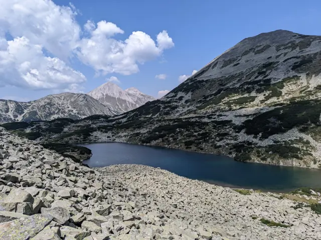
The route from Vihren Hut to Tevno Ezero Shelter via the Tipik peaks is part of the E4 European long-distance path. It is a long high-ridge traverse in the central part of the mountain and, in good weather, offers views of dozens of glacial lakes as it passes alongside or above the Banderishki, Vasilashki, Tipitski, Bashliiski, Chairski, Valyavishki, Prevalski lake groups, ending at the largest of the Malokamenishki lakes - Tevno Ezero. The terrain is alpine throughout, and the peaks the trail crosses or looks out upon are rocky, with grassy sections and occasional juniper and dwarf pine. The total elevation gain is under 1,000 meters, but because the ground is often stony and walking on large, frequently shifting rocks is tiring, the hike requires decent physical endurance. After Bashliyska Porta, there is no water along the main ridge, which makes up the greater part of the hike, so it is a good idea to stock up on plenty before you set off. The section at Tipik peaks is known as "Malkoto Konche" (The Little Horse), drawing a parallel to the knife-edge ridge between Kutelo and Banski Suhodol peaks. The ridge narrows significantly here, but unlike the actual Koncheto, the trail here is not secured with a safety cable. However, this shouldn't deter you, as the more dangerous sections are primarily on the eastern slope of the ridge; therefore, your goal should be to stick to the western side wherever possible. Start of the Route The route begins with a short but fairly steep climb from the parking lot in front of Vihren Hut toward the meadow located southwest of the hut. It then continues through a short section overgrown with dwarf mountain pine until it reaches the small wooden bridge over the Banderitsa River. Along this section, our trail ,marked with red stripes, overlaps with the blue-marked trail leading to Sinanitsa Hut, but the two paths split just before the bridge. We cross the bridge and continue toward the Banderishki Lakes, the first of which is only a five-minute walk away. Okoto Lake After the bridge, there is a sign pointing to the left of the main trail. The short detour it marks will lead us to the small Okoto Lake (The Eye), the first of the Banderitsa Lakes group. It is nestled in a relatively isolated cirque saddle, so when we visit it, we will feel as though we are deep in the mountains, despite actually still being quite close to civilization. The lake reflects the silhouette of the peak Banderishki Chukar, whose pyramidal shape is clearly visible from our vantage point. The Banderitsa Lakes After a short stroll along the right shore of Okoto Lake, we head back down to the main trail. At first, the path runs through the meadow along the river, but it soon begins to gain elevation as the terrain becomes rockier. The next lake in the group, Ribno (The Fish Lake), will appear on our right. Reaching it requires a brief detour from the route. Given that a long and difficult trek lies ahead, we should carefully consider whether we have the energy for such detours by the time we reach the junction for this lake, especially since a little more climbing along our path will soon grant us a view of it from above. There will be no shortage of lakes along the way. As we ascend a bit further, a portion of Ribno Banderishko Lake will reveal itself among the rocks and dwarf mountain pine below us - the detour for which I assume we bypassed. After another 200 meters of elevation gain, the steep trail brings us to the third Banderitshko lake along our route: Zhabeshkoto (The Frog Lake). Here, our path branches off to the right, while the green-marked trail continues straight toward Demyanitsa Hut via Todorina Porta (Todorina Gate). To our right stands the peak Banderishki Chukar, and behind us, on the other side of the Banderitsa River valley, rises another pyramidal peak - Muratov. A short descent follows, bringing us to the shore of Dalgoto (The Long) Banderishko Lake. Beyond this lake, the truly difficult section begins. The Ascent to Bashliyska Porta A steep climb awaits us along a path that can hardly be called a path. We walk over rocks, huge boulders, until we reach the foot of Vazela Peak. Although various guidebooks state that the trail passes through Bashliyska Porta (Bashliyska Gate), the lowest part of the saddle will actually be off to our right, some distance away. Instead, our path will lead us out about a hundred meters below Vazela Peak, where the massive rocks finally end, and the terrain becomes significantly more pleasant and gentle. While we are still going up, however, it is well worth turning around from time to time. Even though this section is physically grueling, it offers, at least for me, the most beautiful view of the entire route: the white peaks of Vihren and Kutelo, the Todorka Ridge to their right, and the Banderishki Lakes below us. Opreno Peak and the Tipitsite From here all the way to Mozgovishka Porta, we walk along the ridge. The terrain varies from boulder fields to grassy meadows, with lakes visible in every direction. For instance, as we approach the next peak, Opreno, we will see a massive lake down to our left. This is the largest of the Vasilashki Lakes - Tevno Lake. Not that Tevno Lake toward which our trail is heading, but Tevno Vasilashko Lake. Although our path doesn't cross every single high point along the ridge, we can always take brief detours if we have the energy to see what lies on the other side, as there is certainly no shortage of interesting sights. Before reaching the first peak of the Tipits group - Golyam Tipits (or Golyam Tipik), we will notice thin, flat rocks appearing along our path. They protrude from the ground, strangely arranged compared to the chaotic rock piles surrounding them. Whether this is a natural phenomenon or the whim of a tourist whose example others followed, I do not know, but it is the only place along the route where you will see it. Malkoto Konche (The Little Little Horse, the duplication is not a mistake) Next is the descent toward the most famous section - the narrow, rocky ridgecrest between Golyam and Malak Tipits, known as Malkoto Konche. Malkoto Konche is a diminutive of a diminutive, since the original ridge Koncheto, after which this one is named, already means The Little Horse, so this one is the little version of the little horse. Not to scare you, but there is no shortage of places where one could fall here. On the other hand, the dangerous sections are brief, and as I mentioned before, if we stick to the trail markings and avoid the detours that go along the left side of the rocky ridge, where the cliffs drop down to the Tipitski Cirque with the Tipitski Lakes below us, we shouldn't have any problems. Prevalski Chukar, Prevala Saddle, and Mozgovishka Porta After the Tipits Peaks, the trail becomes less technically demanding, though it remains physically testing. We will descend a bit, climb back up slightly to Prevalski Chukar, and then descend once again - this time to Prevala, the saddle that separates the Chairski and Prevalski glacial cirques. Here, off to our right, we will spot the Chairski Lakes. Down to our left will be the Prevalski Lakes, and further out, also to the left, the Vasilashki Lakes. I don’t recall exactly which lakes are visible from which precise vantage point, but in this part of Pirin, you certainly won't find any shortage of lakes. Here, a trail branches off to the left from our path, heading toward the Prevalski cirque and Demyanitsa Hut, as well as to the right - passing by the Chairski Lakes toward the Spano Pole Shelter. We continue straight ahead. Next, we skirt around Mozgovishki Chukar, the peak straight ahead of us, traversing its rocky northeastern slope toward the saddle between it and the peak visible to the left, the lower twin of Valyavishki Chukar, which is marked on some maps as Valyavishka Chuka. This saddle is Mozgovishka Porta (Mozgovishka Gate). The Belemeto Cirque, Kamenitsa Peak, and Tevno Lake Once we pass through Mozgovishka Porta, we don't have much further to go until Tevno Lake. Here, a blue-marked trail branches off from our path, heading south toward Begovitsa Hut and north toward Demyanitsa Hut. The red-marked trail, which we continue to follow, skirts around Valyavishka Chuka, and before long, the steep, rocky slope gives way to grassy meadows. Granted, there are still rocks scattered about, but grass begins to dominate the landscape. Kamenitsa Peak comes clearly into view, and after a little more walking, so does Tevno Lake - the largest in the Belemeto cirque. At its far end sits our final destination: the Tevno Ezero Shelter.